
Canter Resources Corp has reported that it has completed a comprehensive 3D model that incorporates all of the recently reinterpreted geophysical data and third-party datasets.
The new 3D model has further refined the understanding of subsurface structures and potential lithium-bearing brine formations covering an expanded 5 by 10KM target area outlined within the central part of the Columbus Lithium-Boron Project.
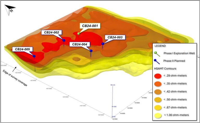
Hybrid Source Audio-Magneto Telluric (HSAMT) geophysical data provides an important guide for targeting conductive bodies, with low resistivity values indicating the presence of highly conductive material interpreted to represent brine fluids within aquifers and pore spaces.
There are numerous examples of lithium-brines correlating to HSAMT resistivity values of <1 ohm metre and the company views the <0.5 ohm-metre resistivity as particularly favourable for potential lithium concentrations (see Figures 1 and 2).
“Our new detailed 3D work integrates our structural and stratigraphic interpretations and provides us with a predictive exploration model that leverages historical drilling and 15 years of reprocessed geophysical data,” stated Joness lang, CEO of Canter. “Most importantly, the 3D rendering of HSAMT resistivity shells shows a very compelling brine target that our team is excited to begin testing with Geoprobe and exploration well drilling during our Phase I program.”
The HSAMT ground-based geophysical method has enabled the mapping of subsurface resistivity through detailed 3D modelling, indicating several resistivity-defined shells spanning a volume extending 5 km wide by 10 km long and down to depths of approximately 600 metres. These highly conductive shells, indicative of brine solutions, are the focus of the company’s lithium enriched targeting efforts.
Supporting the HSAMT data, historical surface sampling and prior drilling in less conductive areas, considered less prospective, have yielded lithium values up to 1600 ppm and boron levels exceeding 10,000 ppm, revealing a multi-tiered aquifer system.
To the company’s knowledge, the upcoming drilling will represent the first drilling within the Columbus Basin that tests zones with resistivity values indicating this degree of conductivity. The priority target area is well within the company’s 23,000-acre Columbus property package and expanding HSAMT coverage will be considered later this year.